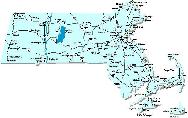
To directly access information about a specific site, click on it in the map.
The weather and sites information in this page is taken a document compiled by Pierre St Hilaire (pierre@media-lab.media.mit.edu).
For windsurfing info on the web, check out my list of windsurfing servers and info.
The weather in New England is well known for it potential for rapid change. It is very difficult to predict even by professional forecasters, which means that local sailors must often depend a lot on their instinct and experience. That task is made simpler if we consider that most sailable days come from either one of 3 types of weather:
Usually the approach of the system is marked by an increase in SW flow. This SW wind is typically at its best within the 12 hours prior to the passage of the cold front associated with the perturbation. The nice thing about this SW flow is that it can be very warm, sometimes resulting in > 50 F temperatures in the middle of winter. The SW flow can result in winds in the 3.5 range in late fall and early spring. More typically one is likely to encounter 4.0 - 5.5 weather. The South Shore (i.e. Duxbury, Buzzards Bay and the Cape) is best at this point.
After the cold front the wind shifts to the NW. If the perturbation is strong enough the NW wind can be quite good (although always very gusty) for about 24 hours after the frontal passage, otherwise the sailing is either marginal or good for just a few hours. The North Shore (Nahant and Plum Island) often gets the best wind in those conditions.
A high pressure system typically follows the perturbation. At that point it is advisable to go back to work as the wind will be dead for a few days.
Preferred wind directions: W-NW, NE
Preferred weather type: I and III
driving time from Cambridge: 1 hour
Sailing is tidal although some sail the channel at low. Level is beginner to intermediate, advanced usually (but not always) go to Plum Island. Be careful about that tide, it pulls unsuspecting novices under the bridge and out to sea! Seabrook Harbor is located on the border between Mass and NH (495N to 95N to Rt 286, follow the signs to Hampton Beach, it's right before the drawbridge).
Preferred wind directions: W - NW, NE
Preferred weather type: I and III
driving time from Cambridge: 1 hour
Plum Island seems to be best after the passage of a cold front in type I weather. It often offers some of the best winds on the coast on NW wind. Be careful, though, as the tidal currents are very strong! For more info, check out the Newburyport Boardsailing Association, and the description of sailing sites around the area.
Directions to Plum Island: take the NewburyPort exit on 95 (495N to 95S!), follow the signs onto the island, up to the Lighthouse ($5 parking in the summer).
Check out the Wind Hotline reported windspeeds from
yesterday, and
annual averages.
A great asset of that site is that is so close to Boston (35 minutes).
It is a good after work sailing site, for those who have real jobs.
Check out the Wind Hotline reported windspeeds from
yesterday, and
annual averages.
There are two launch points: one is in a protected bay (1 mile in
diameter) and the other in the harbour proper (good on SW). The bay is
interesting for beginners, and also in extreme conditions for advanced
sailors. This is a good place to practice your survival skills in
those killer > 50 knots Nor'easters since you can't get blown away too
far. Pleasure Bay shuts down from June to September (type II weather).
Check out the Wind Hotline reported windspeeds from
yesterday, and
annual averages.
In type I weather Duxbury gets usually 1 sail size less wind than the
Cape sites, but sometimes (late fall and early spring especially), the
reverse can happen. Its a good idea to check out Duxbury when driving
out to the Cape, it might save you a lot of driving. Duxbury shuts
down in the summer (type II weather).
On a NE day you can sail either inside the bay or out in the ocean
across the bridge (side-onshore wind). Be aware that in a big
Nor'easter the waves can get well over mast high. Not for the faint of
heart...
Check out the Wind Hotline reported windspeeds from
yesterday, and
annual averages.
Directions: Take exit 8 off route 6 and travel north to route 6a and
then take a right onto 6a (east). Heading East on 6a: Once in Dennis
take a hard left (almost 180 degree angle) at the white and black
signs for some beach cottages. Follow 200 ft and take a right and
follow for about one mile. Take a left at the needlepoint shop.
Follow until you come to the water. Keep going around the dunes until
you reach the parking lot. Parking is limited so arrive early if good
conditions are expected. Heading West on 6a (from Corporation Beach):
Bear right at the white and black sign for the beach cottages. Follow
directions above. (directions courtesy of
HOFFMANT@hcc01.babson.edu)
Check out the Wind Hotline reported windspeeds from
yesterday, and
annual averages.
Kalmus is famous for its summer thermal winds (type II) that blow on
hot days when all other beaches are dead. Those thermals usually bring
5.0 - 6.5 wind in the afternoon with an occasional 4.0 - 4.5 day. The
wind usually picks up late in the morning, slacks down around 5 pm.,
and often picks up again around 6 pm. So, don't be too quick to unrig,
you might miss the best wind of the day! The combination of warm water
in the summer and very constant winds makes Kalmus a good learning
site. On the weekends, however, the site can get quite crowded. From
Memorial Day to Labor day there is a $8.00 parking fee.
Directions: take Rt. 6 on Cape Cod to Exit 6. Go right (south) at
the end of the ramp. Continue with the road through Hyannis. Look for the
signs for the ferry (it's small sign with picture of ferry). Drive past
the ferries, past the Kennedy memorial. About a 1/4 mile after Kennedy
Memorial, Kalmus beach will be at a parking lot on your left.
Check out the Wind Hotline reported windspeeds from
yesterday, and
annual averages.
Note the Chappaquoit is closed to non residents between Memorial Day
and Labor Day.
Check out the Wind
Hotline reported windspeeds from yesterday,
and annual
averages.
Directions: get onto the Mass Pike. Go down about 5 miles and take
290W then take 190N. you will then see an exit that leads to the
Greendale mall (can't miss it) then bear to your left and take the
first exit. There will be a fork in the road, take the right. Now
there is a set of lights, take a left. Soon you will see a YMCA and
the park is right after it. You can also sail at Morgan Park by going
down to the end of the street and taking a left, and following a sign
to Morgan Park. This information was supplied by mattp@nis.accel.worc.k12.ma.us
Compiled by Pierre St Hilaire (pierre@media-lab.media.mit.edu).
Edited and translated to HTML by Ron Weiss
(rweiss@lcs.mit.edu)
Nahant (a.k.a. Lynn Beach)
Preferred wind directions: W - NW
Type of weather: I and III
Driving time from Cambridge:35 min.
The preferred wind directions are W to NW, after a cold front passage.
The launch site is at the end of a long isthmus, with ample parking
space. The wind is offshore in W and NW winds, so the water is flat
with some small chop. It is usually fairly gusty in those conditions.
Nahant can be good in NE with some good waves, but I have found that
Duxbury often has better wind in Nor'easters.
Pleasure Bay
Preferred wind directions: S-SW. NE is also sailable, but gusty.
Preferred type of weather:I
Driving time from Cambridge:20 min.
The great advantage of this site is its proximity: 10 min from
downtown! This makes it a good after work sailing place. The water of
Boston Harbor is not the cleanest around, but is getting cleaner
every year.
Duxbury (a.k.a. Powder Point Bridge)
Preferred wind directions: SW-S-SE , NE
Preferred type of weather: I and III
Driving time from Cambridge: 45 min.
The site is a funnel-shaped bay that extends to the south. Duxbury is
a great sailing spot on SW winds and often gets the strongest NE winds
on the coast. For a few hours after high tide on a SW wind the current
creates Gorge-like conditions, with good ramps. Watch for low tides,
or you might end up doing the "Muck Walk" !. At low tide follow the
locals, they know the channels. Wear shoes as there are lots of broken
clam shells on the bottom.
Corporation Beach
Preferred wind directions: NW-N-NE
Type of weather: I and III
Driving time from Cambridge:1 hr 30 min.
This site is situated on the North side of Cape Cod. It is for expert
wavesailors only as it gets killer waves in winds > 25 knots. On a big
day expect to share the waves with the surfers.
Chapin Beach
Preferred wind directions: NW-N-NE
Type of weather: I and III
Driving time from Cambridge:1 hr 30 min.
About 5-10 minutes down the Cape from Corporation. Good place to sail
on northerly winds. NE winds are a little weak on the inside, but
good for jumps on the outside. It a good stretch of flat water on the
inside, and waves for riding and jumping on the outside. Waves are
usually a little smaller than Corporation, so it's great for
non-experts. Chapin is unsailable during low tide, so make sure to
check the tide charts before you head out there.
Kalmus Beach
Preferred wind directions: W - SW - S
Type of weather: I and II
driving time from Cambridge: 1 hr 30 min.
This is probably the most famous beach in all of Massachusetts, and
for a good reason: Kalmus gets consistenly more wind than any East
Coast site north of Corpus Christi. The water is usually flat with
some chop. The chop becomes larger as you get upwind. SW winds are
side onshore.
West Dennis Beach
Preferred wind directions:W-S-SW
Type of weather:I and II
driving time from Cambridge:1 hr 45 min.
West Dennis is a few miles further along the South facing part of the
Cape and gets essentially the same wind pattern as Kalmus. SW wind is
side-onshore. The beach is nicer than Kalmus and the chop a bit
bigger. There is a sandbar 1000 feet offshore (near the island) than
can create good ramps when the conditions are right. The main
inconvenient is that you have to walk 100 yards in the dunes to launch
between Memorial Day and Labor Day since windsurfers are confined at
the end of the beach. There is also a $8.00 parking fee during that
period. West Dennis beach is a good place to learn in the summer as
the water is warm and the sea breeze very constant.
Chappaquoit Beach
Preferred wind directions: SW - NW
Type of weather: I and II
Driving time from Cambridge:1 hr 15 min.
Chappaquoit is in Buzzards Bay. It is probably the best wavesailing
sites on the Massachussets coast in SW winds. W is straight onshore,
which can make it tricky to pass the shorebreak. On a big day (4.0 and
smaller) expect logo mast waves. Once past the shorebreak you will
encounter big swells that can be mast high in high winds. This beach
seems to attract the most advanced sailors in the area and is a
favorite of Nevin Sayre. If the surf overwhelms you, or you want to
take a break, it is possible to sail in the harbor on the other side
of the road. There you will encounter very flat water and slightly
weaker winds.
Other Sailing Sites
Please send me information about any sites you would like to add...
Indian Lake
Preferred wind directions: NW, SW
Type of weather: I and II
Driving time from Cambridge:45 minutes
The best wind directions are either northwest or southwest because of
the coves that funnel winds in these directions. There is a
sailing/windsurfing club that allows you to store equipment for a fee.
Indian Lake is also the highest point in Worcester (by about 400 feet)
so the wind is usually howling in the spring and fall.
 comments and suggestions are welcome.